India has drone-mapped more than 3.28 lakh villages for property records under the SVAMITVA scheme. That single programme showed how fast aerial data can change the way the country plans land, roads and cities. Navi Mumbai startup Indrones Solutions is building a business around the next step: turning raw flight data into drone geospatial intelligence that engineers and officials can act on.
Founded in 2015, Indrones designs its own survey drones and runs a software suite, Eigen OS, that processes what those drones capture. The company says it has covered more than 5.4 lakh kilometres and completed over 300 deployments in India and abroad.
How Indrones turns flights into drone geospatial intelligence
Indrones works across the full chain, from data capture to decision. Its model combines drones-as-a-service with manufacturing of its own commercial drones, according to a 2023 stock exchange filing by MapmyIndia.
The company describes its setup as decentralised collection and centralised processing. Drone teams fly sites across the country. The data flows into Eigen OS, which the company presented in a February 2026 announcement as the Eigenspace Suite.
What the software does
The suite handles photogrammetry, orthomosaics, 3D point clouds and AI analytics. It combines several sensor types, including standard RGB cameras, multispectral, thermal and LiDAR, and runs quality checks as data arrives, according to the release carried by ThePrint.
Indrones says the pipeline processes data up to 70% faster than conventional workflows. The suite is now listed in the Bentley Systems Ecosystem Catalog, so survey outputs can feed directly into Bentley iTwin digital twins used by infrastructure engineers.
The hardware
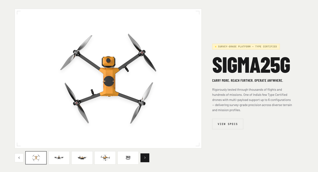
The company’s Sigma 25G is a 2.2 kg carbon-fibre quadcopter with a PPK positioning module for survey-grade accuracy, according to its published flight manual. Indrones says the drone holds DGCA type certification, a requirement for commercial operation under Indian rules.
Why drone geospatial intelligence matters now
Indian drone policy has changed sharply in five years. The Drone Rules 2021 cut the number of forms from 25 to 5 and approvals from 72 to 4, and opened about 90% of Indian airspace as a green zone up to 400 feet, according to a PIB backgrounder from February 2026.
The same document reports 38,575 registered drones and 39,890 certified remote pilots as of February 2026, backed by a production-linked incentive scheme for drones. Supply of flights is no longer the bottleneck. The harder problem is converting terabytes of imagery into measurements, change alerts and models that a project manager trusts.
Government demand shows the scale. Under SVAMITVA, drone surveys have covered about 95% of the target villages, and 2.76 crore property cards have been prepared. The National Geospatial Policy 2022 further opened map data to private Indian firms. Launch91 has seen the same data-to-decision shift in agriculture, through AgriCPS’s satellite crop monitoring and Sensegrass’s soil intelligence platform.
Traction and proof
Indrones sells drone geospatial intelligence to smart cities, government bodies, construction, oil and gas, agriculture, mining and infrastructure. Its 2026 announcement added construction megaprojects, solar and renewables, bridge monitoring and defence to the list.
The company reports:
- More than 5.4 lakh kilometres of drone coverage.
- Over 300 deployments across India and international sites.
- Full compliance with MeitY data-localisation requirements, so client data stays in India.
In February 2023, MapmyIndia, the listed digital mapping company, announced a strategic investment in Indrones. A mapping leader choosing to back a drone data company is a strong signal about where geospatial value is moving.
The team behind Indrones
Pravin Prajapati founded Indrones in 2015 and leads it as CEO. He started the company years before liberalised drone rules, when commercial flying in India required long approval cycles. Building through that period gave the team operating experience few newer entrants have.
Harshad Bhanushali serves as COO. The company is headquartered in Vashi, Navi Mumbai, and Geospatial World lists its team in the 51 to 200 range. Learn more at indrones.com.
Why investors should watch Indrones
The timing. Drone Rules 2021, the drone PLI scheme and the National Geospatial Policy have together created a large, legal market for commercial aerial data in India.
The wedge. Indrones owns both ends of the workflow. Its own type-certified hardware feeds its own processing software, which gives it control over data quality and turnaround.
The business model. Recurring drone geospatial intelligence contracts with infrastructure, energy and government clients, plus software that can be sold to teams who fly their own drones. The Bentley catalogue listing opens a channel to global infrastructure engineers.
The backing. A strategic investment from MapmyIndia links Indrones to India’s best-known mapping platform. The company reports raising between $500,000 and $1 million to date.
The next milestone. Converting Eigen OS from a service tool into a standalone software subscription, with named paying users outside Indrones’ own flight teams, would move the company’s valuation logic from services toward SaaS.
The bigger opportunity
India is spending heavily on roads, railways, power lines and cities, and every one of those projects needs accurate, repeated measurement. Drone geospatial intelligence turns that measurement from an occasional survey into a continuous feed.
Indrones has spent a decade building the drones, the pipeline and the credibility to supply that feed. As infrastructure owners move to digital twins, the company is set to become one of the data layers India builds on.
FAQ
What is drone geospatial intelligence?
Drone geospatial intelligence is the use of drone-captured imagery and sensor data, processed into maps, 3D models and analytics, to help organisations measure sites, track change and make decisions.
What is Eigen OS?
Eigen OS is Indrones’ software suite for processing drone data. It produces orthomosaics, point clouds and AI analytics from RGB, multispectral, thermal and LiDAR inputs.
Who invested in Indrones?
MapmyIndia announced a strategic investment in Indrones in February 2023. The Navi Mumbai company was founded in 2015 by Pravin Prajapati.